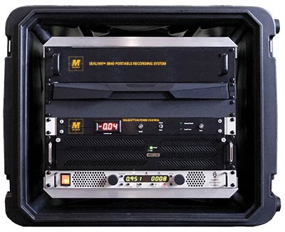
SeaLink 3840 Portable Recording System
The Seamap SeaLink 3840 Portable Recording System was developed to acquire and record large quantities of data in real-time as either a portable or fixed installation onboard a marine seismic vessel. The SeaLink 3840 is excellent for 2D, 3D, High Resolution, and Ultra High Resolution data recording utilizing multiple streamers for seismic surveys.
The SeaLink 3840 Recording System collects 2D and 3D data via the internal Data Array Interface (DAI) cards. The (DAI) integrates perfectly with the SeaLink Solid Streamer and SeaLink 24 Digital Module. The workstation can manage one to four streamers per SeaLink 3840 unit with channel counts from 24 to 240 channels each streamer. The DAI was designed to expand the SeaLink 3840’s multi-streamer functionality to more than 1,500 channels at 2mS sample rate (per array) of seismic data. SeaLink supports sample rates of ¼, ½, 1, 2, and 4ms, adjacent channel summing and continuous recording. The DAI / COMM card are the only custom parts needed to interface with the SeaLink 3840. It exceeds all current wet-end capabilities that are available in today’s market.
The SeaLink architecture allows for future expansion and growth as technology evolves at increasing speeds. Seamap is committed to be on the cutting edge of the latest technology.
Seamap Links
Key Features
- Light Weight and Portable Compact Workstation (2U)
- Rack Mounted in a 10U to 12U Shock Mount Transport Case
- Integrated Aux Box – 6 to 12 Auxiliary Channels
- Integrated Power Supply and GFI
- Capacity 24 to 240 Channels Per Array
- Can Manage up to 4 Arrays per Workstation with one DAI
- Efficient Memory (Dynamically Allocated Memory Buffers)
- Virtually Zero “Dead Time” (Continuous Recording)
- Sample Rates of ¼, ½, 1, 2, and 4ms
- Adjacent Channel Summing: 2:1, 3:1
- Online & Offline Quality Control
- Built in Array Simulator and Test Pattern Generator
- Seismic Data Saved to Hard Drive, LAN, or SCSI Device
- Optional: Data Storage LTO’s NAS’s RAD’s
Applications
- Geo-Engineering
- Geo-technical Surveys
- Environmental Studies
- Ultra High Resolution Marine Seismic – 2D / 3D & 4D
- Transition Zone Seismic
- Passive Seismic


