Exploration
Exploration is part of the upstream segment of the oil and gas industry that includes the search and exploration phases of the business. Exploration is one of the earliest parts of the oil and gas production process. Surveys are performed to help identify the areas that have the most potential to hold these resources. The process can involve seismology both onshore and offshore, both of which use substantial vibrations as a result of releasing very precise volumes of air at very specific timings (acoustic energy) to create seismic waves. How the seismic waves interact with a reservoir containing oil and gas help to pinpoint the reservoir’s location.
Exploration is also a crucial part of the Renewables and Construction Survey markets. Both make use of the refraction seismic technique described above, but the data collected is focused much shallower in the subsurface. These “site surveys” are performed to gather information about subsurface conditions at the site proposed for construction. The data collected provides a full understanding of the occurrence of soil and rock strata, locations of ground water tables and any variations, engineering properties of the soil, and various other information that allow for the selection of the best type of foundation and selection of the appropriate construction equipment for the project.
Would you like more information about our Exploration Solutions?

Applications
Marine Seismic
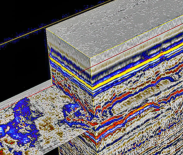
Marine Seismic surveys use near surface induced seismic pulses to image the subsurface. A seismic wave is generated underneath the earth’s surface, and the returns are picked up by hydrophone arrays known as “streamers” that are towed by a ship.
MIND Technology through our Seamap line of products, offers an extensive range of marine seismic products based on leading edge engineering design, development and production. We provide real time solutions that give our customers the advantage in an ever increasingly competitive industry.
We design and manufacture the world’s leading real-time seismic acquisition and source control system, the GunLink range. We also design and manufacture the industry leading real-time GPS buoy tracking and positioning system, BuoyLink 4DX, as well as our SeaLink 3840 Marine Streamer Seismic Recording System used for the acquisition of 2D, 3D, High Resolution, and Ultra High Resolution data.
Seamap has acquired the reputation for quality and reliability amongst all customers. Our client base comprises the majority of the largest seismic companies currently operating worldwide, plus we also support small to medium sized companies with the same care and level of attention to detail. We offer 24/7 support, and repair facilities helping our customers avoid downtime at all costs.

Construction Survey
Construction surveys require high resolution bottom imagery and sub-bottom profiling for improved project decision support.
Underwater construction surveys are routinely undertaken for the planning, routing, installation, monitoring and remediation of marine infrastructure in the offshore energy, pipeline/cable, port development, inland waterway and reservoir/dam industry segments. These surveys are often conducted in arduous conditions.
Construction surveys require the acquisition of the high quality bottom imagery, hydrographic data and foundation information, to support mission-critical projects.
MIND Technology, through our Klein product line, has a wide range of side scan sonars, bathymetry sonars and sub-bottom profilers which are extensively used to provide the high quality acoustic data necessary for improved project decision support.

Renewable Survey
Offshore Renewable Energy projects such as wind, tide and wave energy applications need to minimize and mitigate the risks posed by ground conditions by performing Geophysical Surveys.
With the significant increase in the scale and number of offshore renewable energy projects, some of the more significant risks that developers of renewables projects face are the hazards and uncertainties that ground conditions present to project development, design, construction and operation. The primary sources of information that are used to minimize and mitigate the risks posed by ground conditions and geohazards are complimentary geotechnical (intrusive) and geophysical (remote sensing) methods, also known as ground investigations and site investigations.
MIND Technology, through our Seamap and Klein product lines, has expanded our product offering to Include our SeaLink geophysical data acquisition system with higher sample frequency capability for even better resolution of structural information about the ground and its engineering properties. Geophysical methods can be used to quickly and non-invasively provide valuable information on hazards, UXO, and ground conditions.

Product Lines